April 21, 2021

China, and going home

 June 22, 2018

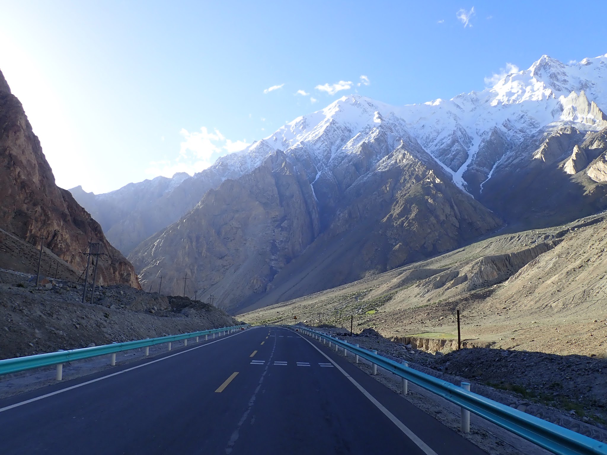
We had camped only a few kilometres from the border, so we were there early before it opened. It was a cold morning and we employed the standard bike trick of sneaking to the front of the line, past the trucks. Once parked, we hung out in our puffy jackets, chatting with curious truckers while we waited for the border to open. Mustagh Ata loomed high above us, its summit brushing the clouds above 7500m.


Leaving Tajikistan was easy, just the usual formalities and passport stamping. The Chinese side was a bit more involved, but still not as invasive as we had been expecting.  In contrast to the control zone on the Tajik side, the Chinese control zone is much stricter. We weren’t allowed to ride the 14km between the first checkpoint and the passport control office, so we hitched a ride with one of the truckers we had been chatting with earlier. They X-rayed all of our panniers but didn’t tear them apart, and despite hearing that it was mandatory, they didn’t search our phone or laptop. Unfortunately, they did confiscate all of our fruit and vegetables, as well as our eggs. This amounted to almost all of the food we had packed to make it to Kashgar, still over 200km away. We were left with a few packs of noodles, some crushed cookies, some sugar-coated peanuts and no local currency.

By early afternoon, we were through the border and on the Karakorum highway. The mountains here are just incredible, and we were riding on the smoothest pavement we’d seen since Turkey. The Chinese sure know how to build roads. Mustagh Ata still dominated the skyline, and after a very unwelcome climb, we started our final descent into Kashgar.


Still so high in the mountains, the views were unreal. Yaks and camels dotted the roadside and we tried not to think about our empty food pannier. Water was becoming an issue too, there was a stream next to the road but it was choked with garbage and looked pretty unappetizing. We eventually filled up from a small lake that looked a bit cleaner than anything else, despite the yak poop on the banks. Camping options were slim, and wild camping is actually illegal in Xinjiang, so we had to be extra cautious not to be seen. We ended up sleeping in a big storm drain underneath the highway, probably the least glamorous location imaginable for the final night of our trip.


In the morning we split our last package of instant noodles and continued our descent. With the climb straight out of the border we were still up above 4000m, despite some descending the previous day. We had a long way to go to Kashgar, down at 1200m. It ended up being one hell of a day. Our food stash was down to some cookie crumbs and a handful of peanuts, and our water was running low. We had no Chinese money and no way to get any. And, to be totally honest, we were just done. Done riding bikes, done camping, done mentally and physically. So, we decided to just go for it. As with all roads, it’s never all downhill, even when you’re descending 3000m in a day. There were some epic smooth descents where we flew around corners, leaning into turns like the bikes were extensions of our bodies. There was also a lot of flat or slightly uphill slogging.  We were hungry and thirsty but the sudden increase in oxygen as we got lower made me feel amazing. I spent part of the day in a detached, trance-like state, where I felt like I had moved past the need for food or water. I was just pedaling, just riding; my existence in the moment was nothing more and nothing less.


By early afternoon, our water was long gone. Despite being high on oxygen, we were dangerously dehydrated and getting close to crashing. I had started eyeing the water in the ditch next to the road and wondering if I was that desperate. About 40km from Kashgar a car pulled over and a very happy man jumped out and handed Steve a water bottle. Steve chugged it, and showed the guy his empty bottles. Laughing, the guy reached into his car and handed us a few more bottles. He gestured enthusiastically to the bike that was jammed into his back seat, shook our hands, and drove off. How did we even get this lucky?

By the time we got to Kashgar we had ridden 168km that day, so eager to be finished biking that we had done it before 3pm. We checked into a hostel, parked the bikes... and that was it. There was no big fanfare, no huge arrival. One minute we were on a long, cross-continent bike tour, and then suddenly we were done. 


Well, we weren’t quite done. We spent a week in Kashgar sorting out logistics, booking flights, and packing up the bikes. That time was also used to explore the city a bit. Steve had visited this place 10 years earlier, and was pretty shocked to see what had changed in that time. Many people have written about the current situation in Xinjiang with much more knowledge and insight than I will be able to muster. I’ll keep it pretty simple; there’s a scary amount of surveillance and police presence and control over who can move around the city. The Chinese government is essentially ethnic-cleansing its Uigher population, complete with “Re-education” camps and restrictions on any practices, clothing or grooming related to their religion or culture. It’s pretty horrifying.  They’ve also bulldozed the original Old City and replaced it with a fake, Disneyland style “Old City”. It didn’t affect us much as tourists, we moved through all the checkpoints and past the roaming gangs of police thugs with no trouble. We’re not the ones they’re trying to control.

From Kashgar we flew to Chengdu, where we spent a few days being tourists without bikes, and then we flew home. My parents picked us up at the airport, and our trip was officially over.


It was a strange feeling to be back in Canada, surrounded by all the familiarity of home and a language we spoke fluently. It was even more surreal to think that just 2 weeks earlier we had been camping high on a remote plateau in the Pamirs, surrounded by wind and rocks and snow. And that quite a few of the people we had met over the last months were still out there, pedaling away, while we sat on the couch drinking coffee.

When we first set out from Iceland, there were so many questions about what lay ahead. We always do a ton of research and preparation so we know what’s coming, but there’s only so much you can prepare for. There are always so many unknowns. I had so many things on my mind, so many pieces of the puzzle floating around with nowhere yet to fit. I thought about the weather in Iceland. Wild camping in Europe. Riding in the winter. The Shengen Visa. Border crossings and safety, traffic and bad drivers. Landmines in Bosnia. Ferries in Greece.  Crossing the Caspian Sea. Visas, money, food, and water. Desert crossings and limited supplies. Altitude. Camping on the Afghan border. Water levels in the Bartang. Staying healthy and strong and able to pedal. Which routes to choose? Which decisions were the right ones? Was this entire plan too dangerous and foolhardy to pull off? There were so many thoughts and plans and potential situations bouncing around in my head, taking up space and energy. Slowly, over the months we were riding, they disappeared. Each one surfaced as we came to it, and then faded as we dealt with it and moved to the next one. As we were nearing the end, especially after we had decided that it actually was the end, my mind felt so free. It was so satisfying, to look back and realize that every single doubt or concern was surmountable, and that we had figured it all out and pulled it off.

It has taken me almost 3 years to finish writing about our trip. We got busy and life happened, but the incomplete blog was always there, nagging in the back of my mind.   One of the best things I did while riding is that I kept a journal, where I wrote a little bit about every single day we were gone. It’s the only way I was able to remember everything well enough to write about it now. It’s been fun re-reading my journal, looking at all the pictures, and re-living our days on the bikes.

We’d talked about doing this trip for a few years before getting around to it. After our first bike trip through Spain and West Africa, we had aspirations of tackling something a bit bigger. One night, Steve just said something along the lines of “life is so uncertain and you never know what will happen. If there’s something we want to do, we should do it now, before we can’t.”  They were wise words, and it was the motivation we needed to make it happen.

Especially right now, with a global pandemic and various states of lockdown and travel restrictions around the world, I feel pretty fortunate that we were able to do this trip. Sure, we put a lot of effort into making it happen, but we also got very lucky, and benefited so much from the people we met. I think anyone who travels by bike will say that they receive so much generosity from strangers, and our trip was no exception. So many people helped us along the way, whether it was roadside snacks, a place to put our tent, or just a friendly wave as we passed. In addition to these small strokes of luck, we started out pretty lucky. It’s a huge amount of privilege to be able to put your entire life on hold and go for a really long bike ride. Not to mention having passports and a nationality that is welcomed and appreciated all over the world. It also helped knowing that back home, friends and family were following along and rooting for us.

We couldn’t have been happier with how it turned out, including all the highs and lows, and hard days when we wanted nothing more than to quit but somehow kept going. So many amazing things that we experienced didn’t even make it to the blog, because we could never include it all. We remain even more convinced that a bicycle is a wonderful way to travel. All this, plus being able to share it with my sister and her partner, who just so happened to be on a similar epic trip at the same time? Truly, we couldn’t have planned it better.

Since no post is complete without a roundup, here it is:


Iceland to China:

Starting point: Keflavik, Iceland – Oct 14 2017

Finishing point: Kashgar, China – June 22 2018

Total distance pedaled: 11,749 km

Distance traveled as a percentage of the circumference of the earth: 29.4%

Total days: 253; or 8.5 months

Number of Countries visited: 20

Number of Countries banned from: 26

Number of currencies used: 16

Most time spent in a country: 35 days (Turkey)

Least time spent in a country: 8 hours (Austria)

Highest point: 4655m (Ak Baital Pass, Tajikistan)

Lowest point: -28m (Caspian Sea)

Longest day: 168km (Our very last day, riding into Kashgar)

Top Speed: 82.7 km/h

Flat tires: 7 (3 for Steve, 4 for Elaine)

Crashes: 4 (1 for Steve, 3 for Elaine)

Number of Ferries taken: 9

Number of nights spent in the tent: 115

Coldest riding temperature: -8C

Hottest riding temperature: 52.8C

Top 3 hardest days:

-  Day 245, climbing the switchbacks out of the Bartang Valley, Tajikistan.

-  Day 248, Over Ak-Baital Pass to Murghab, Tajikistan.

-  Day 123, Outrunning a storm to Sarande, Albania.

Best drivers: Poland

Worst drivers: Georgia

Cheapest beer: Sarajevo, Bosnia (2L for $1.50)

Most expensive beer: Torshavn, Faeroe Islands (a pint for $10)

Birthdays celebrated on the road: 2 (Dubrovnik for Steve, Uzbek desert for Elaine)

Most important item that we couldn’t survive without: Cookies.

Time between finishing the trip and finishing the blog: 1,034 days (almost 3 years)


Tajikistan Part 2: The Bartang Valley, Karakul, and Murghab

June 2018

After a brief delay involving a closed gas station and doubling back to fill our fuel bottles, we reached our turnoff and started up the Bartang Valley. We had only ridden a few kilometres when we ran into a German couple who had come from Khorog the day before. We rode with them for most of the day, chatting about our trips and life and the things you chat about when you run into other cyclists on a long tour. They’d met Karen and Jamie in Khorog and were delighted to realize that we were sisters! This was actually a common theme from people who ran into us separately. Most tourists on the road here were European, and they all had a good laugh that the only Canadians they did meet were related.

The first part of the valley was pretty easy riding, bumpy but not too bad, though in some places it was just a track through sand and rocks that seemed like it spent a good portion of the year underwater. The valley was beautiful, we passed villages and farms tucked in between river and mountains. My words don’t do it justice; I’m not sure if the pictures will either. We pushed on after the Germans stopped and found a nice little rock garden to sleep in, tucked underneath steep cliffs on either side. It was a great day, one of those days that make us want to keep riding forever. It was also reassuring to have such a good start to a section I was feeling so unsure about.


The next day the road was still rideable, but definitely getting worse and harder. We cranked up lots of short steep climbs and were rewarded with fun, flowy descents on packed sand. There were a few sections where the road had been taken over by water, so we were just riding up the streams. Even so, it was peaceful riding in an amazing location, so we were enjoying the challenges. We had been lucky so far and hadn’t had any big river crossings, so we were making good time. Not quite halfway up the valley was the town of Savnob, which had a small shop that was the only place to get food.  Savnob was guarded by a huge climb, which we came upon right at the end of the second day. The climbs were starting to get bumpier and steeper, and the well stocked panniers were feeling pretty heavy. So we found some abandoned houses to camp beside and decided to tackle the climb after a rest. In the morning, after what felt like a great deal of effort, we pedaled/pushed up and over the hill to Savnob.

As we rolled into the town a few people came out to greet us, and a very helpful man said that he would show us to the shop. As expected, it was pretty sparse, but we bought some noodles and cookies and Snickers bars. Almost 3 years later, I still can’t eat a Snickers without thinking of Central Asia; they were a staple. 


The road continued to deteriorate. We were still enjoying the ride, but the suffer-fest was starting. The Bartang Valley climbs about 2000m of elevation over about 300km, with quite a few extra ups and downs in there. The road became less of a road and more of a rocky trail as we moved higher up the valley. If it wasn’t for the location, this ride would have been a lot worse. Even as we were suffering with the loaded bikes, the mountain views just kept getting more and more stunning. The feeling of remoteness was increasing too; the farms and villages that occupied the lower parts of the valley were long gone and we hadn't seen a vehicle in days. Now it was mostly rocks and a hint of a road that was sometimes just a faint track across dry floodplains. At the end of the third day, we came into Gudara, which was the last town we would see for a few days. It didn’t have a shop, but we stopped for a water refill, and we ran into two American cyclists heading down the valley. We had a quick chat with them, and were pretty relieved to know that everything coming up was passable! Until this point we had still been expecting some challenging river crossings. They assured us that there was nothing to worry about, and we did the same for them.

Out of Gudara we had another steep rocky climb that there was no hope of pedaling up. So we pushed, and a friendly young guy on the road stopped to help me push my beast of a bike up the hill. I tried to tell him how much I appreciated the help, and I hope he understood. At the top of that hill, we set up camp and ate dinner on a rock, surrounded by epic mountains and looking back down the valley at where we had come from. My words really will never be able to describe the beauty of this place.


The next day, our 4th day from Rushon, ended up being the hardest day of the entire trip. We had come to the end of the Bartang Valley, and it was time to climb up some switchbacks to gain the alpine plateau that would lead us back to the M41. We started early and even though we could see the terrain that would take us up and over, it took most of the day to get there. A combination of the huge peaks distorting the distance, and the bad road meant that we didn’t actually hit the switchbacks until the afternoon. When we did get to the switchbacks, we discovered that they were steeper, rockier, and looser than we had been expecting. There was minimal pedaling and mostly pushing. Quite often, we would both push one bike through a section before going back down to get the second. The views, however, were incredible. We could see the river bed so far below us, the channels streaking across the sandy ground and huge peaks rising up above it all. The colours were so vibrant and the air was so clear. We kept slogging, because that’s all there was to do. By the time we made it to the top, we had done almost 1000m of elevation that day and were both destroyed. About ¾ of the way up, I had been joking to Steve that it couldn’t be that hard, because I hadn’t cried yet. I almost made it, but just as we crested the last little hill, the tears came. I sat in the dirt and sobbed while some shaggy donkeys watched from a distance.

And then we kept riding, because that’s all there was to do. We were up above 3800m now and the views up on the plateau were even more stunning. We rode into a huge, yellow fertile valley, surrounded on all sides by craggy, snowy mountains that stretched up into the sky and dwarfed the world below them. There was a shepard there who invited us into his hut, but we were too wrecked to socialize. So we kept riding and eventually found a little creek to camp next to. As exhausted as we were, it was pretty rewarding to be up so high on this plateau, surrounded on all sides by this spectacular scenery that made us feel so small.


We probably could have made it back to the M41 the next day, but I got hit hard with food poisoning and an afternoon snowstorm rolled in, so we stopped early. I didn’t feel great for a few days, but we kept riding, mostly because we were running out of food and needed to make it somewhere to resupply. The rest of the plateau was decent riding, mostly sandy tracks, sprawling mountains, and fuzzy marmots chirping at us from their hidey-holes.  We came across an alpine desert with tiny purple and white flowers poking up from the sand, and a hazy view of Lake Karakul in the distance. After a handful of easy river crossings, our tires hit pavement for the first time since leaving Rushon. It was a good feeling, knowing that we’d accomplished our goal of riding up the Bartang Valley and were back on the Pamir highway.

Our next move was a choice between riding towards Karakul, which was 25km in the wrong direction, or heading the other way towards Murghab, over 100km away. We were pretty low on food, so we rode into Karakul. The place looked mostly abandoned, and the one small shop had some noodles and not much else, but we did find a Chaihana that cooked us up a hot lunch. It was nice to be in a Chaihana again, just like the desert Chaihanas in Uzbekistan, but in the mountains. After the first good meal in days, we doubled back towards Murghab. We climbed a bit at the end of the day and spent the night tucked into a moonscape just above 4000m.


Maybe the next day was the hardest of the trip? It’s hard to say. We started off strong, climbing up towards the highest pass on the Pamir highway. We’d been able to exchange a few messages with Karen and Jamie who were in Murghab. They said they would wait for us to get there, and we were feeling pretty good that we could make it there that night.  It was probably a combination of the elevation, and the fact that I still hadn’t fully recovered from the food poisoning. But climbing up that pass just about broke me. It took everything I had, pushing my bike even on the mellow sections, with Steve’s help. As usual though, one foot in front of the other eventually got us up to 4655m, the top of Ak-Baital Pass and the high point of our trip. We snapped a picture where I look about as dead as I felt, and started our descent towards Murghab.

Eventually, far later than we’d planned and exhausted by a headwind on top of everything else, we rolled into the Pamir Hotel in Murghab. Luckily the kitchen was still open so we sat down for a much needed hot meal with Karen and Jamie, sharing all our stories since Dushanbe. They had taken the also challenging  Wakhan Valley route through the Pamirs, so we stayed up late laughing about all the bad roads, tears, and absurdities that had brought us this far. 


Murghab was a welcome sight, but not exactly a place we wanted to linger. The only power to the hotel came from a generator, which was turned on for about 4 hours in the evening. Any hot showers or charging of electronics had to happen during that time. We made a trip to the market, which is housed in a collection of old shipping containers, and found some eggs and dried fruit in addition to the standard noodles and cookies. It was interesting to get a glimpse of life in such a remote place, but we were eager to carry on.

Somewhere along the way, between melting in the desert and struggling in the mountains, Steve and I had decided that we were done bike touring. For real this time, and the fact that we’d considered this before and kept riding made us even more confident that this was the right decision. The Kulma Pass border between Tajikistan and China had recently re-opened after being closed to foreigners for years. It seemed like a natural exit point, to cross Kulma Pass, ride the Karakorum highway into Kashgar, and go home from there. So that’s what we decided to do. Karen and Jamie left the next morning, heading towards Ak-Baital pass, and Kyrgystan beyond. They ended up riding for another 2 months, spending time in Kyrgystan and China, and eventually flying home from Hanoi. Steve and I rode towards China, feeling pretty satisfied with what we had accomplished, and with absolutely no regrets that we were down to our last few hundred kilometres.

About 50km out of Murghab we entered the border control area, where the soldiers checked our visas and let us through. In no hurry, we climbed up towards the pass, through rolling yellow meadows covered with the little alpine wildflowers we had gotten used to seeing everywhere. About 10km from the border, some soldiers pulled over to tell us that the checkpoint was closed for the night, but that we could camp in the control zone. Our last night in Tajikistan was spent at 4300m, surrounded by wildflowers, near a remote border outpost high in the mountains. Once again, the stars were epic and the night was dark and silent. It was a fitting end to one of the hardest, wildest, and most memorable countries of the trip.


Tajikistan Round-up

ODO start: 10 384 km

ODO Finish: 11 496 km

Total distance: 1123 km

Actual Country name: Jumhurii Tojikiston

Days in country: 25

Nights camped: 13

Flat tires: 1 (Elaine)

Crashes: 0

Broken spokes in the middle of nowhere: 3

Broken chains in the middle of nowhere: 7

Distance ridden along the Afghan border: 174 km

Time to have bike parts delivered to our hostel from Russia because the owner “knew a guy in Moscow”: 36 hours.

Number of Snickers eaten: Too many

Other cyclists met on the road: Dozens


Tajikistan Part 1: Dushanbe to Rushon

June 2018

It was late in the day by the time we were through the border and into Tajikistan. We rode only as far as it took to find somewhere to camp, which was a snarled little forest tucked into an industrial area. The tent just barely fit and we had a tree in our vestibule. But it was out of sight and we were tired, so we ate leftover samosas on the lumpy ground and then fell asleep.  


The next day we rode into Dushanbe, fighting heavy traffic and road closures that led us on a very unwelcome detour to get across the city to our hostel. We ended up staying in Dushanbe for about a week, between one thing and another. Steve got food poisoning, we had some major bike work to do, and we really needed the rest. Karen and Jamie arrived the day after we did, so we also wanted to catch up with them after a week apart.

From Dushanbe there was a choice of two routes to reach the Pamir highway. The southern road is longer, but with less elevation and better pavement. Karen and Jamie opted for this one. The northern route, which until quite recently was the only option, is a bad road, a high pass, and isn’t open all year due to snow and rockslides. The night before we left Dushanbe, another cyclist posted online that he had just ridden it and it was good to go. We chose the northern route.

The first days were nothing special. We were pretty unmotivated. It was still hot and the air was so dusty we couldn’t see much. Part of the reason we’d chosen this road was for the views, but with everything obscured by the dust, it just felt like we were suffering on a bumpy dusty road for nothing. Luckily though, on the second night we had a good thunderstorm and woke up to gorgeous clear skies. We passed the first of many police checkpoints and turned into a narrow canyon and, as promised, the scenery was beautiful. The rain had freshened up the air and livened up the colours. The trees were lush and green, the rocks and the hills were bright red and the rivers were swollen with spring run-off and red sediment. The road was pretty rough by now, but also quiet. We were more likely to get held up by a flock of sheep or a mob of children than by traffic, so it was peaceful riding.  Quite often we would ride through streams that were flowing across the road, most of the time keeping dry feet but getting the occasional soaker. Our spirits were up, as these are the kind of roads that we enjoy the most. The temperature was downright enjoyable after what we’d had in Uzbekistan, and we started passing patches of snow as we got higher. At one point we came across a recently cleared landslide, and rode past without any trouble. Later, we heard a rumour that another cyclist had spent an entire day scrambling his bike and gear across it less than a week before we passed by.


We spent another 2 days climbing, through quiet villages full of friendly kids who loved to wave and come practise their English with us. The final part of the climb was a huge, long contour across one entire side of the valley, which brought us up to 3252m, our new trip high point.  There were signs warning of landmines at the summit, so we bombed down the other side, bikes rattling on the bumpy gravel until the sun started to set. Our home that night was an epic perch on top of a cliff overlooking a rocky canyon. The sky was clear and the stars were the brightest I’ve ever seen. We lay with our heads hanging out of the tent door for a long time, just gazing up. 


The next morning we had more bumpy downhill riding, following the canyon as it took us back down to 1200m. It was one of the more epic descents of the trip, with awe-inspiring mountain views the entire way and a sheer drop off to the raging river far below. We stopped in Kalai Khum to re-supply, knowing that this was the last decent grocery store we would see for a few weeks. This town is the spot where the northern and southern routes from Dushanbe meet again, so from here we were back on the main road.

For the next few days we followed the road along the Panj River, which forms the border between Tajikistan and Afghanistan. It was really interesting to peer across the river at the Afghan villages on the other side. We have such a negative image of Afghanistan in our minds from living in North America and only hearing about wars, but this part of the country was lovely. We saw cute tidy villages tucked into the landscape, with people buzzing by on motorbikes on their side of the river. Kids were swimming and playing in the river, yelling “hello!” and waving at us as we passed. The kids on the Tajik side were just as friendly, and we stopped multiple times a day to respond to the usual questions: “Where are you from? What is your name? Where are you going?” Sometimes the kids were picking and selling apricots, so we had a much appreciated supply of fresh fruit too.


I had been a bit nervous about spending this much time on the border, especially when it came to camping. Because it’s so long, relatively remote, and not very well patrolled, it’s an area known for drug trafficking.  A few weeks before we arrived, there had been some vague rumours on the internet about some cyclists maybe being shot at, or hearing gunshots, but it wasn’t really clear if this had actually happened or not. The general advice for riding here was to stay aware, camp out of sight, and trust your intuition if something doesn’t feel right. Anyone running drugs probably doesn’t want to run into you either. As it turned out, we had some great campsites along this part, tucked away above the road, with the lights from across the river dotting the dark hills. We only heard one loud bang in the distance that could have been a gunshot, but was probably a car. The second night, as we were setting up, a big gust of wind grabbed the tent out of our hands and threatened to blow it across to Afghanistan. We chased it down the hill and caught it by a guyline, relieved that we didn’t have to consider an illegal border crossing to retrieve it.


A week after leaving Dushanbe we arrived in Rushon, which is pretty small and doesn’t have much to offer a tourist. For us though, it marked the point where we would turn off the main road and head up into the Bartang Valley. The true Pamir Highway route follows the M41 the entire way through the mountains, but there are a few little side roads and detours you can take, depending on the adventure you want.  We didn’t know much about the Bartang Valley, but from what we had heard it was pretty remote and not always passable if the water levels were too high. It sounded like something we wanted to try. We knew there was one small shop about halfway up the valley but that it probably only had noodles and chocolate bars, so we had to leave Rushon with most of what we would need for about 6 or 7 days. We found a little guesthouse and did what we could to pack food for a week. It wasn’t the most satisfying shop, but we found cheese, noodles, eggs, and some fresh fruit. It seemed a bit sparse for a week of hard riding, but it would have to do. At the last minute we found some cans of sardines and a box of baby porridge that we added to try and bulk up our calories.

I definitely felt a bit anxious the night before starting up the valley. Mainly because there were so many unknowns, between road quality (not good, we had heard) and water levels. Even after months on the bikes, the unknowns make it hard to estimate how fast we could move and if we would run low on food or not. But we had prepared the best we could, and worrying wouldn’t change anything, so eventually I pushed my doubts aside and managed to get some sleep.